Download Now
Automapki x64 1.3.3
Download Now
See full specifications
Publisher's descriptionOS Support: Win7 x64, Win Vista
Version 1.3.3
Size 112.50Mb
Hits: 642 visitors
Downloads: 267
License: Shareware
Price: 40 USD (Buy Now)
Date added: 15 Oct 2013
Last Update: 10 Feb 2013
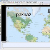
Automapki application brings web mapping and commonly available satellite imagery to autocad / zwcad / Bricscad software. Our Automapki application allows to display your project and working area on top of your favourite web mapping source, either Bing Maps, Google Maps, Yahoo Maps or Open Street Maps. It works with standard AutoCAD / ZWCAD / Bricscad and any vertical product, supports over 3000 coordinate systems and allows the whole global CAD users community to stylize drawing entities with the selected web mapping provider.
Available Translations: None
Popular related
Powerful 3D/image/video files organizer/viewer/editor (+80 formats supported)
autocad | gis | web map | mapguide | satellite imagery | zwcad | bricscad |
 suggest to a friend
 report error
 add to my alerts